Launch of the first of the announced satellites is expected as early as summer 1997. It can be assumed that the testing and calibration phase will last for the first year of operations. It has to be noted, however, that the schedule for all of the announced satellites already had to be delayed several times.
In the meantime, we are in the position to simulate the high
resolution satellite imagery from airborne scanner images of
comparable spatial resolution. The imagery was recorded by a DAEDALUS
AADS 1268 line scanner with N=10 spectral bands on board a Dornier
Do 228 aircraft during five campaigns from 1991 to 1997 in cooperation
with the German Aerospace Research Establishment (DLR) at flight
altitudes of 300 m, 900 m and 1800 m. The 300 m imagery has a
nadir-looking ground resolution of 70 cm. Due to the panorama
characteristic of so-called `whisk broom' - line scanners and the
large swath angle of ![]() 43
43![]() , the ground resolution degrades to
1.40 m towards the image margins. The resolution is usually also
slightly degraded by the resampling process required by georeferencing
(which is compulsory for a number of applications). On average, the
images have a resolution of 1 m, equally for all 10 spectral bands.
, the ground resolution degrades to
1.40 m towards the image margins. The resolution is usually also
slightly degraded by the resampling process required by georeferencing
(which is compulsory for a number of applications). On average, the
images have a resolution of 1 m, equally for all 10 spectral bands.
For all environmental image analysis purposes it is essential to have a spectral band in the near infrared (NIR). There, vegetation has a very high reflectance and is the most distinct from non-vegetation land cover. Also, plant health and plant stress show up in the increase of reflectance between the red and the NIR. Therefore we have simulated a photographic CIR image, where the spectral bands of Green, Red and the (invisible) Near Infrared (G,R,NIR) are coded by Blue, Green and Red (R,G,B), respectively, and merged into a composite pseudo-color image.
The specifications of the high resolution satellites indicate that the 1 m resolution will only be reached for the panchromatic imagery. The spectrally resolved bands will come in a spatial resolution of only 4 m. We have simulated both the panchromatic full resolution image (Figure 1, by weighted average of the spectral bands) and the spectral band images (Figure 2, by averaging each 4x4 pixel window into one new pixel).
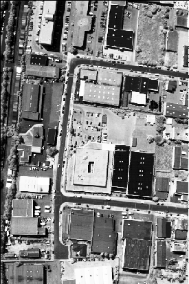
Figure 1: Panchromatic image of urban area near the airport of
Nürnberg, resolution 1 m.
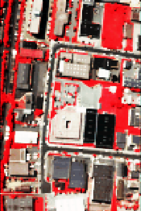
Figure 2: Simulated color infrared image of urban area,
resolution 4 m.